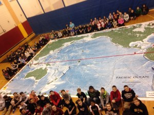
WILMINGTON, MA – Students at the Wilmington Middle School dove into the wonders of the Pacific Ocean with one of the world’s largest maps of the world’s largest ocean. Measuring 26 feet by 35 feet, the map gave students a fun, interactive experience through rich content and exciting activities that enliven the study of geography. Designed for grades K-8, the map was loaned to the Wilmington Middle School last week through National Geographic’s Giant Traveling Maps program, managed by National Geographic Live, the public programming division of the National Geographic Society. The Pacific Ocean maps and curriculum were developed and funded by two $1 million Oracle Commitment Grants, awarded to National Geographic.
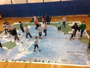
The brightly colored, smooth vinyl surface of the map allowed Wilmington students to explore some of the unexpected geography at the bottom of the Pacific Ocean: from the deepest place on earth, the Mariana Trench, to the world’s tallest mountain, Hawaii’s Mauna Kea, which has its base on the ocean floor. Most of all, students experienced the Pacific as a living entity, with active volcanoes giving birth to new islands, deep sea vents supporting new life forms, phytoplankton blooms providing over half of the planet’s fresh air, and the Great Barrier Reef, the largest living structure in the world.
Teachers at the Wilmington Middle School were also provided with a set of fun, content-rich activities to help students interact with the map: “Cities in the Sea” invited students to explore the extraordinary biodiversity of four reef ecosystems; “The Deep & the Dark” simulated for students the depth of the Mariana Trench and fifteen other ocean floor trenches; and “Ocean Commotion” allowed students to travel the ocean surface along the paths of eight major currents, finishing in the middle of the Pacific garbage patch, where they learn about human impacts on ocean health. Also accompanying the maps were lavish photo cards of animals and plants, hand-held models of volcanoes, and colorful coral reef replicas.
“The kids really enjoyed walking on the map and were very interested in learning about the Pacific Ocean,” said WMS Grade 7 Social Studies Teacher Dana Robinson, who organized the event. “This opportunity was made possible through a grant from SEMAGNET (Southeast Massachusetts Geography Network) and Bridgewater State University. Professor Vernon Domingo oversaw the scheduling of the map expositions. University representatives delivered and picked up the map.”
“We are excited to share this new map with audiences around the United States. Maps of this size are a powerful medium for helping young people relate to the world,” said Dan Beaupré, National Geographic’s director of education partnerships for National Geographic Live. “We believe these giant Pacific maps will be an effective tool for creating responsible stewards of our planet.”
“The Giant Traveling Maps program is an innovative way to engage and inspire students to learn about science and the world,” said Colleen Cassity, executive director of the Oracle Education Foundation and Oracle Giving & Volunteers. “We have awarded National Geographic two grants to support their science and environmental education efforts. We are proud to support the launch of the new map as part of this effort.”
National Geographic’s Giant Traveling Maps program was introduced in 2006 with a map of Africa created after National Geographic magazine’s 2005 special issue devoted entirely to that continent. Since then the program has expanded to include maps of North America, Asia and South America, Europe, and the Pacific Ocean. In the 2013-2014 school year hundreds of thousands students will interact with these maps. In addition to school venues, the maps appear at museums, festivals, fairs, and corporate and educational conferences. The maps also reinforce National Geographic’s commitment to increasing geo-literacy through teacher professional development, K-12 curriculum, live events, and academic competitions.
To learn more about the Giant Traveling Map project, for borrowing information or to download map activities, visit www.nationalgeographic.com/giantmaps.
(The above press release was provided by National Geographic. A few modifications were made.)