WILMINGTON, MA — On Monday, June 29, the Wilmington Open Space Committee met at Town Hall to discuss the town’s new 5-year Open Space and Recreation Plan, which will soon be submitted to the state for approval.
Based on town-wide survey results and feedback at a prior public workshop, the Committee has created a plan that will:
- add more walking, jogging and biking trails in Wilmington
- add a dog park in Wilmington
- add water features (e.g., splash pads) to some parks in Wilmington
- add more picnic spaces to some parks in Wilmington
- complete the Yentile Farm Recreational Facility
- improve handicap accessibility at town parks and Silver Lake
- continue to protect the town’s natural resources and open space areas
“This summer is ‘Open Space Summer’ in my office,” said an excited Valerie Gingrich, Wilmington’s Planning and Conservation Director, who will soon be getting started on many of the plan’s goals.
Selectman Chair Mike Champoux, who serves on the Open Space Committee, emphasized the importance of taking an inventory and mapping all the town’s natural resources as a first step.
“Let’s put some parking in some of these places, put some signage up, and take credit for some of our wonderful natural resources,” said Champoux.
Gingrich noted the public has sent a clear message to the Committee – the town is doing a good job with its playgrounds and playing fields, but it – in particular – needs to increase its number of paths for runners, walkers and bike riders.
“And we don’t have to be trailblazers,” noted Champoux. “We can save some time and money by leveraging the successes and failures of neighboring communities [who created a network of trails] before we go down this path.”
Read the plan below. The plan consists of THREE main goals. Each goal has THREE main objectives. Each objective has several actions. Each action has an estimated timeline in parentheses.
Goal: The town wants to provide opportunities for mobility locally and regionally with walking and biking trails.
Objective: The town will map existing trails and provide education regarding existing resources.
- Using hand-held GPS, collect location data for existing trails: conservation subdivisions, Town Forest, and other trails (Summer/Fall 2015)
- Map location data on digital map system such as Town GIS and/or Google Maps (Winter 2015/2016)
- Assess amenities at existing trails and identify needs for signage and access (2015-2016)
- Announce maps on Town website, local paper and social media (Spring 2016)
- Recruit volunteers for work days and adopt-a-trail programs to maintain trails (ongoing)
Objective: The town will create new trails and connect existing trails with new sidewalks, new open space and private development of conservation subdivisions.
- Identify town-owned parcels that could serve as connections to existing trails or could add to the overall trail network (Summer/Fall 2015)
- Construct trail connections on private subdivisions and public lands (2016-2019)
- Identify locations where sidewalks could serve as connections to the trail network (2016-2017)
- Construct sidewalk improvements (ongoing)
- Establish general rules for trail use (2018)
Objective: The town will work with others to provide access along the Middlesex Canal path.
- Map historic Middlesex Canal path (Winter 2016/2017)
- Identify access points and locations where path could be formalized in the short term (2017)
- Create cohesive, low maintenance design for implementation (2018-2019)
Goal: The town will balance resources to meet open space demands and provide a variety of open space amenities for a full range of users and interests.
Objective: The town will create a buying guide that would provide new accessible features with each purchase of park furniture or equipment and address accessibility shortfalls identified in the facility assessments attached to this plan to provide more inclusive and accessible facilities and opportunities.
- Create policy for purchase of ADA compliant furnishings with new purchases (2015-2016)
- Connect hard surface access points at Silver Lake (2015)
- Fix access to fishing pier at Silver Lake to make flush (2016)
- Smooth transition between driveway and bleachers at Town Park (2016)
- Assess and adjust access points at Rotary Park (parking lots, buildings, playground) (2016)
- Add handicap sign to the second parking space at entry to Rotary Park (2016)
- Assess use and adjust access to building at Robert Palmer Park (2018)
Objective: The town will identify locations that could be appropriate for water features or splash pads, dog park and picnic areas and construct amenities.
- Assess existing park locations for the inclusion of a splash pad (2016)
- Identify locations for a dog park and construct in the short term. (2016)
- Identify locations in existing parks that would be appropriate for picnic areas (co-locate where other amenities currently exist) (2015-2018)
- Plan new locations where new water features and dog parks could be located (2017-2019)
Objective: The town will construct the Yentile Recreational Facility to provide a wide range of amenities for various age groups and a playing field that can be used by a range of sports to take pressure off of the Town’s existing facilities.
- Complete permitting process for the Yentile Farm Recreational Facility (2015)
- Construct the Yentile Farm Recreational Facility (2016-2017)
Goal: The town will protect its natural resources and open space areas that support water protection, flood management and essential wildlife habitat and ecosystems.
Objective: The town will work with land owners and other interested parties to protect privately owned properties identified for protecting water resources (e.g., wetlands, surface waters, and ground waters) and wildlife and their habitats to sustain and strengthen biodiversity.
- Encourage use of conservation subdivisions and cluster development that avoid valuable natural resource areas (ongoing)
- Educate landowners about the benefits of conservation restrictions (ongoing)
- Accept donations of land that will serve as resource protection and habitat (ongoing)
Objective: The town will identify town-owned parcels that would be best used as resource protection areas and that could be transferred to the Conservation Commission.
- Update Assessor’s records to reflect transfers of land to conservation (2017)
- Using GIS, identify potential parcels for resource areas (2018)
- Conduct site visits to assess extent of wetlands, resource areas and site attributes (2018-2019)
- Transfer appropriate parcels to care and custody of Conservation Commission
Objective: The town will develop a greenway along waterways and link waterways with protected uplands to improve wildlife habitats, to promote water quality, and to provide recreational opportunities.
- Using GIS, identify parcels that would serve as links to existing open spaces (2017)
- Identify locations where greenway would be publicly owned and accessible (2018)
- Where links are privately owned, assess potential for acquisition or other method for protection (2019)
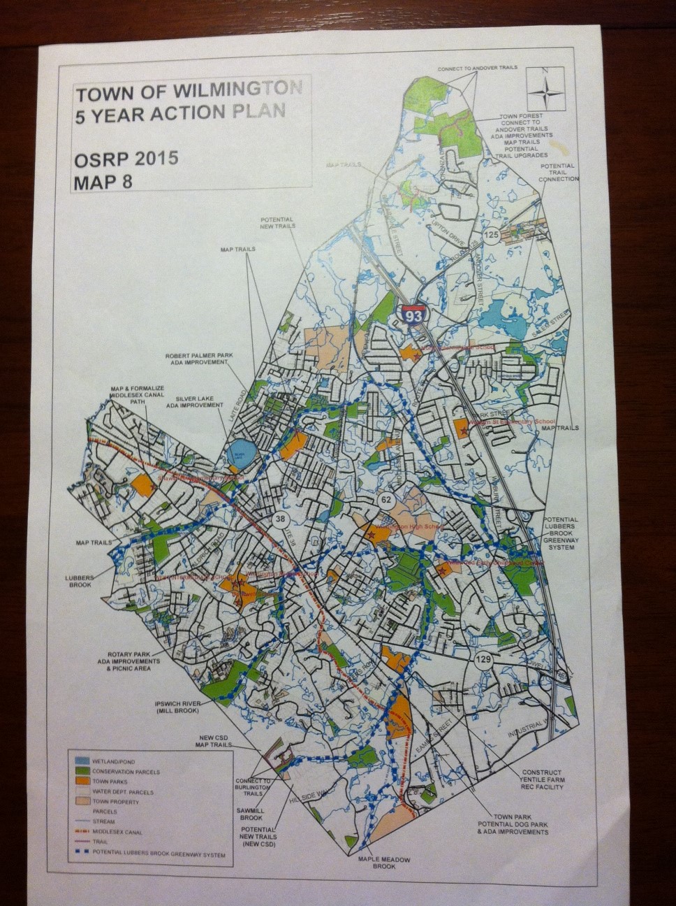
Below is a map identifying many of these projects over the next 5 years! (Get your magnifying glass out!)
Like Wilmington Apple on Facebook! Follow Wilmington Apple on Twitter! Subscribe to Wilmington Apple’s daily email newsletter HERE! Got a comment, question, photo, press release, or news tip? Email wilmingtonapple@gmail.com!
